
2019, ISBN: 1566953480
[EAN: 9781566953481], Libro nuovo, [SC: 18.32], [PU: NATL GEOGRAPHIC MAPS Jan 2019], TRAVEL - UNITED STATES; / STATES SOUTH EAST CENTRAL (AL, KY, MS, TN); ATLANTIC (DC, DE, FL, GA, MD, NC… mais…
| AbeBooks.it AHA-Books, Einbeck, Germany [86569176] [Rating: 3 (su 5)] NEW BOOK. Custos de envio: EUR 18.32 Details... |

New River Gorge National River Trails Illustrated National Parks National Geographic Trails Illustrated Map - Livro de bolso
2008, ISBN: 9781566953481
Softcover, New Book. Shipped from UK in 4 to 14 days. Established seller since 2000. Please note we cannot offer an expedited shipping service from the UK., [PU: National Geographic Maps … mais…
| alibris.co.uk |
New River Gorge National River (Trails Illustrated Map #242) (National Geographic Maps: Trails Illustrated) - livro usado
2009, ISBN: 9781566953481
Natl Geographic Society Maps, 2009-01-01. 3. Map. Used: Good., Natl Geographic Society Maps, 2009-01-01, 2.5
| Biblio.co.uk |
ISBN: 9781566953481
New River Gorge National River, West Virginia New-River-Gorge-National-River-West-Virginia~~National-Geographic-Maps Undefined>Undefined>Undefined Other Format, National Geographic Maps
| BarnesandNoble.com new Custos de envio:plus verzendkosten., mais custos de envio Details... |

2012, ISBN: 9781566953481
Trails Illustrated National Parks, Karte/Globus, Karte (gefalzt), 2019th ed. [PU: National Geographic Maps], National Geographic Maps, 2012
| lehmanns.de Custos de envio:Versand in 7-10 Tagen. (EUR 0.00) Details... |

no/na AbeBooks.it
2019, ISBN: 1566953480
[EAN: 9781566953481], Libro nuovo, [SC: 18.32], [PU: NATL GEOGRAPHIC MAPS Jan 2019], TRAVEL - UNITED STATES; / STATES SOUTH EAST CENTRAL (AL, KY, MS, TN); ATLANTIC (DC, DE, FL, GA, MD, NC… mais…

National Geographic Maps:
New River Gorge National River Trails Illustrated National Parks National Geographic Trails Illustrated Map - Livro de bolso2008, ISBN: 9781566953481
Softcover, New Book. Shipped from UK in 4 to 14 days. Established seller since 2000. Please note we cannot offer an expedited shipping service from the UK., [PU: National Geographic Maps … mais…
no/na Biblio.co.uk
New River Gorge National River (Trails Illustrated Map #242) (National Geographic Maps: Trails Illustrated) - livro usado
2009
ISBN: 9781566953481
Natl Geographic Society Maps, 2009-01-01. 3. Map. Used: Good., Natl Geographic Society Maps, 2009-01-01, 2.5
ISBN: 9781566953481
New River Gorge National River, West Virginia New-River-Gorge-National-River-West-Virginia~~National-Geographic-Maps Undefined>Undefined>Undefined Other Format, National Geographic Maps
2012, ISBN: 9781566953481
Trails Illustrated National Parks, Karte/Globus, Karte (gefalzt), 2019th ed. [PU: National Geographic Maps], National Geographic Maps, 2012
Dados bibliográficos do melhor livro correspondente

| Autor: | |
| Título: | |
| Número ISBN: |
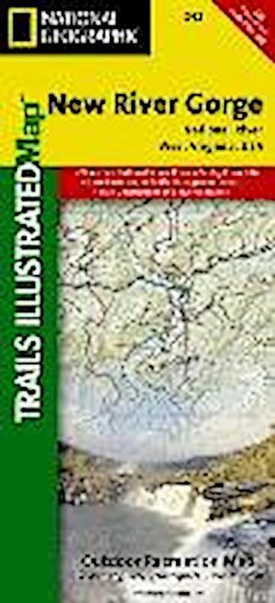
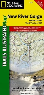
• Waterproof • Tear-Resistant • Topographic Map
Fifty-three miles of West Virginia's New River and its gorge, and forty miles of its tributaries, are preserved as New River Gorge National River, Gauley River National Recreation Area, and Bluestone National Scenic River. Expertly researched and created in partnership with local land management agencies, National Geographic's Trails Illustrated map of New River Gorge National River offers an unparalleled tool for exploring this beautiful riparian region. Key areas of interest featured on this map include Summerville Lake and Babcock, Little Beaver, Pipestem, Carnifex Ferry Battlefield, and Hawks Nest state parks. A detailed inset of Canyon Rim is provided in the print version of this map.
Extensive trail summaries with location, distance, and use will help you choose the path that's right for you. River mileage is noted for those exploring by boat. Recreation features are clearly marked, including campgrounds, trailheads, picnic areas, boat launches, whitewater access, fishing and swimming areas, marinas, and boat rental locations. Helpful agency contact information and safety tips are included as well. The map base includes contour lines, shaded relief, and elevations for summits and passes.
Every Trails Illustrated map is printed on "Backcountry Tough" waterproof, tear-resistant paper. A full UTM grid is printed on the map to aid with GPS navigation.
Other features found on this map include: Bluestone Lake, Flat Top Mountain, Gauley River, Greenbrier River, New River Gorge.
Map Scale = 1:55,000Sheet Size = 25.5" x 37.75"Folded Size = 4.25" x 9.25"Dados detalhados do livro - New River Gorge National River
EAN (ISBN-13): 9781566953481
ISBN (ISBN-10): 1566953480
Livro de bolso
Ano de publicação: 2010
Editor/Editora: National Geographic Maps
2 Páginas
Língua: eng/Englisch
Livro na base de dados desde 2012-03-20T11:35:47-03:00 (Sao Paulo)
Página de detalhes modificada pela última vez em 2023-07-21T15:18:17-03:00 (Sao Paulo)
Número ISBN/EAN: 1566953480
Número ISBN - Ortografia alternativa:
1-56695-348-0, 978-1-56695-348-1
Ortografia alternativa e termos de pesquisa relacionados:
Autor do livro: national geographic maps
Título do livro: west virginia
Dados da editora
Título: New River Gorge - National Geographic Trails Illustrated USA Südosten
Editora: National Geographic Maps
Língua: Inglês
9,99 € (DE)
10,30 € (AT)
Not available (reason unspecified)
CB; GEF; Karten, Globen / Reisen/Karten, Stadtpläne, Atlanten/Nordamerika, Mittelamerika; Landkarten und Atlanten; Nordamerika (USA und Kanada)
Outros livros adicionais, que poderiam ser muito similares com este livro:
Último livro semelhante:
0749717010215 New River Gorge National River Map (National Geographic Trails Illustrated Map, 242) (National Geographic Maps)
- 0749717010215 New River Gorge National River Map (National Geographic Trails Illustrated Map, 242) (National Geographic Maps)
- 0749717012219 Death Valley National Park Map: Topographic Map (National Geographic Trails Illustrated Map, Band 221) (National Geographic Maps)
- Grand Teton National Park (National Geographic Trails Illustrated Map) (National Geographic Maps-Trails Illustrated)
< Para arquivar...